Earth Blox dataset review: MODIS Net Primary Productivity (NPP) Dataset
MODIS Net Primary Productivity (NPP) is the most consistent long-term global record of terrestrial carbon fixation since 2001. Iain Woodhouse explores how it underpins TNFD and CSRD reporting, baseline setting, and the assessment of chronic nature-related risk.
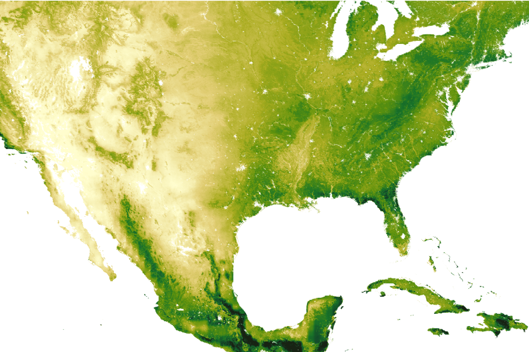
For over two decades, the Moderate Resolution Imaging Spectroradiometer (MODIS) instruments aboard NASA’s Terra and Aqua satellites have provided consistent insights into our planet's vegetation. This review explores the MODIS Net Primary Productivity (NPP) product — specifically the improved, gap-filled version 6.1 (MOD17A3HGF) — and its newfound role as a cornerstone for nature disclosure under frameworks like the Taskforce on Nature-related Financial Disclosures (TNFD) and the Corporate Sustainability Reporting Directive (CSRD).
The MODIS NPP dataset moves us beyond simple indices to a physical measurement of carbon accumulation. It quantifies the "metabolism" of an ecosystem — how much atmospheric carbon is actually converted into plant biomass. In terms of assessing the changing health of an ecosystem, this is the key metric.
Earth Blox verdict
The MODIS NPP product is the most significant long-term record of global terrestrial productivity available to the scientific and commercial communities. While newer sensors like Sentinel-2 offer higher spatial resolution, they lack the twenty-four-year (2001 - present) historical archive that MODIS provides. This historical depth is an essential requirement for establishing the "reference state" of an ecosystem, a key component of the new regulatory reporting standards in Europe and beyond.
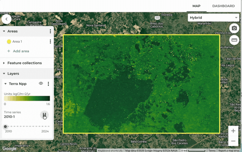
An example of Modis Terra NPP in the Brazilian Cerrado. You can see how, over time, there are areas that are disturbed that lead to the loss of functionality of the ecosystem. This is an important metric to gauge the impact on ecosystems from human activity.
The MODIS NPP dataset is a workhorse for global and regional ecosystem monitoring. Its ability to provide a continuous, twenty-year annual trend of carbon fixation makes it an asset for for identifying chronic ecosystem degradation. While its 500-meter spatial resolution makes it less well suited for monitoring of individual assets or features, it is optimal for assessing portfolio-level exposure to nature-related physical risks across vast agricultural regions or forested biomes.
By implementing sophisticated gap-filling for cloud-contaminated pixels, NASA has created a dataset that is robust enough for use in formal disclosures, where data integrity and consistency are paramount. It allows users to ask: Is the biological productivity of this landscape declining over time, and if so, how does that impact the credit risk of the assets sitting upon it?
Features and assessment
Satellite/sensor: Terra and Aqua / MODIS (Moderate Resolution Imaging Spectroradiometer)
Primary metric: Net Primary Productivity (NPP) in kg C/m²/year
✅ Temporal consistency: With a record starting in 2001, it provides the longitudinal data necessary to differentiate between short-term weather shocks and long-term ecological decline.
✅ Physical units: NPP is measured in kilograms of carbon per square meter, allowing it to be directly integrated into natural capital accounting and carbon risk models.
✅ Gap-filled accuracy: Version 6.1 significantly reduces the "noise" caused by cloud cover through linear interpolation of high-quality neighbour pixels, providing a smoother annual result.
✅ Global standard: It is one of the most-cited datasets in ecological literature, ensuring that the disclosures built upon it are defensible and scientifically rigorous.
✅ Free and open: The data is provided as a public good by NASA, allowing for cost-effective integration into commercial risk platforms.
Cons:
❌ Spatial coarseness: At 500m, the pixels are too large to detect small-scale deforestation or localised damage within a fragmented urban-rural landscape.
❌ Annual latency: Because the product requires a full year of 8-day composites to be processed and gap-filled, it is an "after-the-fact" reporting tool rather than a real-time monitoring system.
❌ Cloud persistence: In the wettest tropical regions, even v6.1 gap-filling may struggle if clear-sky observations are too sparse throughout the year.
❌ Algorithmic complexity: NPP is a modelled product, not a direct measurement. It relies on Biome Property Look-Up Tables (BPLUT) which, while accurate globally, may have regional variances.
Technical specifications
The MOD17A3HGF version 6.1 product is a Level 4 data product, meaning it is the result of a highly processed model that integrates multiple satellite data streams and meteorological observations.
The mission and the science
What is the MODIS NPP Mission?
The MODIS NPP product was conceived as part of NASA’s Earth Observing System (EOS) to study the role of the terrestrial biosphere in the global carbon cycle. Before MODIS, our understanding of global productivity was limited to coarse-resolution models or sporadic ground measurements. The MOD17 algorithm provides the first global, continuous estimate of how much carbon is being sequestered by vegetation across the entire planet.
As well as being useful for estimating carbon exchange, changes in NPP are also an indicator of ecosystem health, and are used as input to other ecosystem measures such as the Ecosystem Integrity Index.
For financial institutions, NPP is essentially the "EBITDA of the ecosystem." If Gross Primary Productivity (GPP) is the "revenue" (total carbon fixed via photosynthesis), NPP is the "net profit" (carbon remaining after the plant has paid its "operating expenses" for maintenance and growth). This net profit is what actually accumulates as wood, fibre, and soil carbon, making it the fundamental driver of value for the forestry and agricultural sectors.
How is the data created?
The science behind MODIS NPP is rooted in the Light Use Efficiency (LUE) logic. It posits that the productivity of vegetation is a function of how much solar energy it absorbs and how efficiently it converts that energy into biomass. The algorithm integrates three primary inputs:
Vegetation greenness (FPAR/LAI): Derived from the MOD15 product, this tells the model what fraction of incoming sunlight is being absorbed by the leaves.
Meteorology: Daily temperature and water stress (vapour pressure deficit) data are used to adjust the efficiency of photosynthesis. If it is too cold or too dry, the plants "shut down," even if the sun is shining.
Biome type: The model uses the MODIS land cover product (MCD12Q1) to assign specific physiological parameters to different vegetation types. An evergreen forest in the Pacific Northwest has a different metabolic efficiency than a savanna in Sub-Saharan Africa.
Version 6.1 implements an improved Level-1B calibration that accounts for the sensor's ageing, meaning that a measurement from 2000 is directly comparable to one from 2024.
The importance of gap-filling
In remote sensing, a missing pixel is more than just a hole in a map; it is a break in the chain of evidence. Earlier versions of the MODIS NPP product were often criticised for "black holes" in tropical regions where persistent clouds blocked the sensor. The v6.1 "Gap-Filled" product solves this by using the temporal context. If the sensor missed a week in May, the model uses the clear-sky observations from surrounding weeks and years to interpolate the likely productivity. This provides a continuous "wall-to-wall" map that is essential for decision makers who need a complete picture across the globe.
Terra vs Aqua
There are two identical MODIS instruments, one on each of the Terra and Aqua satellites operated by NASA. The only difference between these is that Terra passes from north to south in the morning (roughly 10:30 a.m. local time), while Aqua passes south to north in the afternoon (roughly 1:30 p.m. local time). The data, therefore differs in solar illumination conditions and cloud cover. While Earth Blox offers both NPP datasets, we recommend using Terra-NPP for studies of ecosystems on the land surface because it has more cloud-free observations.
Benefits
The narrative of nature-related reporting is rapidly moving from "why" to "how." MODIS NPP data provides a practical pathway for companies to meet the rigorous requirements of new disclosure frameworks. For instance, the TNFD’s LEAP framework (Locate, Evaluate, Assess, Prepare) requires a spatially explicit understanding of an organisation’s interface with nature. NPP is a high-utility metric across multiple steps of this process.
Many businesses rely indirectly on ecosystem "provisioning services." NPP quantifies these services, enabling businesses and institutions to monitor natural assets' productivity trends. This provides an early warning for "dependency risk" for assets like cotton fields (textile lenders) or forests (timber Real Estate Investment Trusts).
NPP is also sensitive to "chronic" physical risks, such as declining soil fertility or invasive species, which take time to develop and start to have an impact. A significant downward NPP trend, even without land-use change, signals a loss of "ecosystem integrity," a material risk for businesses tied to land health.
Reporting on ecosystem condition
The European Sustainability Reporting Standard E4, for example, requires metrics that reflect the functional state of ecosystems. NPP is a primary functional metric. It tells the regulator not just that there is a forest, but how well that forest is functioning as a carbon-fixing engine.
A core challenge of CSRD is determining the "reference state"— the condition against which current impacts are measured. Because the MODIS NPP archive goes back to 2000, it allows companies to establish a reliable 20-year baseline.
For firms with direct holdings in agriculture or forestry, NPP data is a vital tool for risk management.
The MODIS vs. VIIRS transition
At the time of writing, the MODIS Terra/Aqua era is coming to an end and is being replaced by the VIIRS Joint Polar Satellite System (JPSS). The Aqua MODIS instrument will end around August 2026, and the Terra MODIS instrument around January 2027. The VIIRS data will ensure that the NPP record continues for at least another two decades. This continuity is vital for Earth Blox users who require stable, long-term datasets to incorporate into decision-making systems.
While VIIRS offers higher resolution in some bands, the "long-term record" is still held by MODIS. For financial disclosures that require a decade or more of history, MODIS is still the essential starting point. However, users should be aware that the two datasets are being "cross-calibrated" to ensure that we can transition from MODIS to VIIRS without losing the continuity of the record.
Conclusion: A tool for rigorous nature disclosure
The MODIS NPP dataset (MOD17A3HGF) is more than just a map of plants; it is a map of the Earth’s life-support capacity. It offers a scientifically rigorous, data-led pathway to understanding nature-related risks and dependencies, and the health of our ecosystems. While its 500-meter resolution requires a level of regional perspective, its twenty-year archive provides the "temporal authority" that is currently lacking in many newer datasets. As we work toward a nature-positive future, the MODIS NPP product is a valuable asset in our planetary monitoring toolkit, helping us to enlighten the markets with the true value of nature.
Iain is a Professor of Applied Earth Observation at Edinburgh University, specialising in active remote sensing. He has over 27 years experience in academia and industry, 100+ publications, and advises UK government agencies on EO strategy.