The Copernicus Sentinel-1 mission delivers high-resolution, cloud-free radar imagery every week. Iain Woodhouse explores how its unique capabilities help Earth Blox users monitor change with confidence.
The Copernicus Sentinel-1 mission is a European, high-resolution, imaging radar mission that offers weekly cloud-free imagery over most of the globe. It is designed to monitor changes in land surface conditions as part of the European Union's Copernicus Programme for Earth observation and began operation in October 2014. The mission consists of two identical satellites working together to provide more frequent measurements.
Earth Blox verdict
The incredible thing about Sentinel-1 data is that across most of the world, you get an image every 6 days – in Europe it is 3 days. And the acquisition guaranteed, and with an archive going back 10 years. That makes a huge difference when trying to monitor land surface change, such as crop growth, compared to the cloudy images often collected by Sentinel-2 or Landsat. And with a 10m pixel size, it is an incredible, freely available data source that supports a wide range of environmental, societal, and economic applications. The real challenge is that radar has a reputation for being difficult to work with, so it is not as widely used as it should be. Fortunately, it is very straightforward to use Sentinel-1 data in Earth Blox.
Pros:
✅ Can see through clouds and in the dark, so has guaranteed image collection.
✅ Very high nominal revisit frequency (~3 days in Europe, but nearer 16 days elsewhere).
✅ A long-term commitment to the continuity of service so you can plan commercial services into the future, confident of the supply of data.
✅ High-quality calibration (better than commercial sensors), allowing for more sensitive measurements.
✅ A free and open data policy. Makes it highly accessible for a wide range of users and applications.
✅ Can be used for a wide range of applications over land, ice and coastal regions.
Cons:
❌ It only has two bands, so the range of information contained in the data is limited compared to many other missions.
❌ The spatial resolution is still relatively poor compared to commercial alternatives (which can typically be 1-4m).
❌ Some of the idiosyncratic features of radar data can be a problem in mountainous areas.
❌ It is raw imagery, not a data product, so you do need some technical knowledge to use the data effectively.
Technical specs
Ground sample distance (pixel size): two bands at 10m.
Coverage: Global terrestrial surface.
Metrics: Sentinel-1 measures two polarisations (horizontal and vertical) but transmits only one of these. The result is two “bands”: VV (transmit vertical, receive vertical) and VH (transmit vertical and receive horizontal).
Frequency: 6-day minimum revisit period with down to 3-days in Europe.
Expert review
What is the mission?
Sentinel-1 was the first of the Copernicus series of Sentinel satellites. The Copernicus Programme is the European Union's Earth Observation flagship program, designed to monitor the planet and its environment to enhance understanding and provide benefits to European citizens through improved monitoring and reporting. It is also designed to promote European companies that offer space data services by providing a free and open data policy and a long-term commitment to providing the data up to and beyond 2035.
Sentinel-1 is particularly valuable because Synthetic Aperture Radar (SAR) can penetrate clouds and operate day and night, offering all-weather capabilities.
Sentinel-1 is nominally a pair of satellites. 1A and 1B were the original satellites, whereas 1C now replaces 1B following its failure in December 2021. Since 1C was not launched until December 2024, there is a 3-year period where coverage is lower than normal, especially outside of Europe.
What kind of data is it?
Sentinel-1 carries an imaging radar system that measures in the microwave range (with a 5cm wavelength). The wavelength chosen was to provide continuity with previous European radar satellites, giving comparable data back to 1991. Over the land surface, it is most suited to monitoring agricultural crops, urban areas, and infrastructure.
The two polarisation bands help to differentiate some features on the land surface, and when used together, can help to provide insight into crop growth and other vegetation change. It is not well-suited to mapping properties of full-cover forest, but it can generate forest/non-forest maps.
One of the most incredible aspects of Sentinel -1 is its ability to measure tiny ground movements that are indicative of infrastructure problems such as subsidence or structural problems. These measurements can be made over months or years and can be as small as millimetres per year. Get in touch if you want to know more.
How does the data perform?
Sentinel-1 has the longest archive of continuous, open-access, radar imagery covering the land surface. Now that it has collected a decade of data, it now becomes more relevant for forest carbon projects that necessitate setting a baseline over the previous 10 years, even though the data is non-optimum for forest mapping, per se.
Radar imagers do have some idiosyncratic features. The most notable is the noise-like, grainy appearance of radar imagery – this is known as speckle. Radar imagery in Earth Blox has some speckle reduction applied, but you will still notice that it looks noisier than an equivalent Sentinel 2 image.
The other is that areas of high topography will exhibit changes in the image due to the direction in which the image was created. This is why Earth Blox defaults to taking the average of both the ascending and descending paths since they view the ground surface from different directions. (You can filter for one of these only).
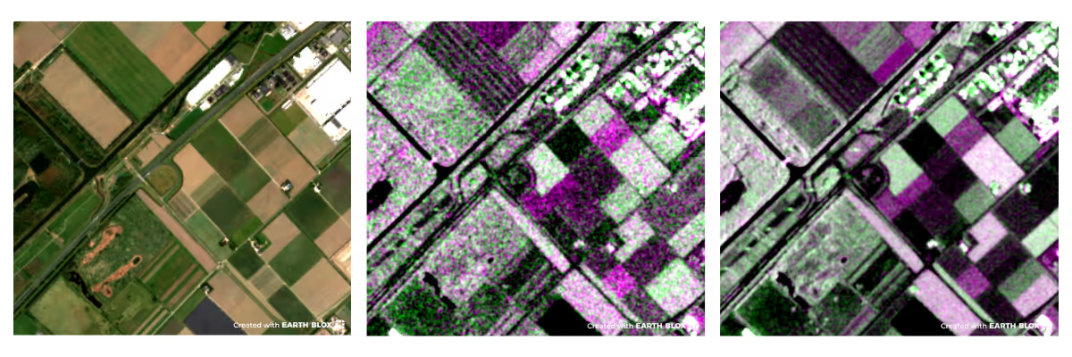
Comparing Sentinels 1 and 2 in Earth Blox. All three of these images have 10m pixels. The first is Sentinel-2, and the second is Sentinel 1. Note how the noise-like granularity of the speckle impacts the visibility of the Sentinel-1. The last image shows a temporal average of the Sentinel-1 image, which reduces the speckle.
What is the data good for?
Due to its consistent wide coverage monitoring capability, Sentinel-1 is ideal for looking at short time scale changes (weeks) for such things as agricultural crops, coastal change, soil moisture variations and shipping. Since data coverage is guaranteed, Sentinel 1 also has an important role in post-disaster response.
In addition to the imagery provided, Sentinel-1 is also optimised for the technique of interferometry. At one level, this can be used for mapping areas of change, such as forest loss due to wind damage, but it can also map millimetre scale movements in buildings and infrastructure due to subsidence or other ground movement.
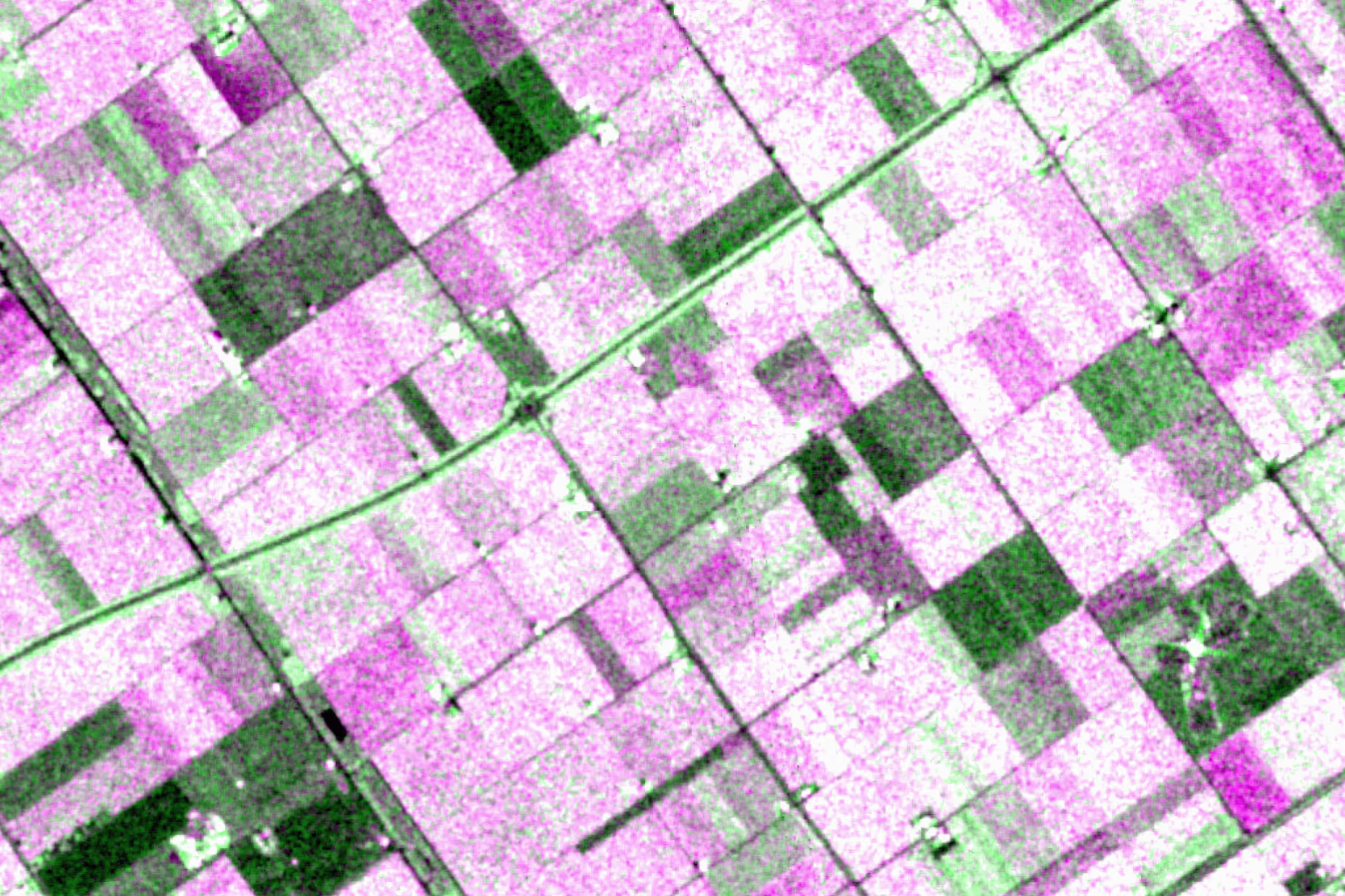
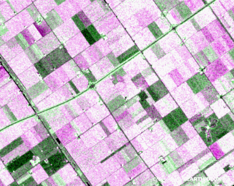
A Sentinel-1 time series showing one growing season over farmland in the Netherlands. Note how rich the information content is at the level of individual fields. The different colours represent different polarisations.
What level of detail does it detect?
Sentinel 1 comes as 10m pixels (ground spacing), but it is important to note that the actual spatial resolution is 20m. This is another one of those radar idiosyncrasies that catches many people out. The impact of speckle also means that while the image has 10m pixels like Sentinel 2, the images do not look quite as good as a cloud-free Sentinel 2 image.
Suggested alternatives
PalSAR ScanSAR
If you are interested in forests, wetlands and mangroves, the individual PalSAR ScanSAR data on Earth Blox may be more suited to your needs. However, the coverage is sporadic and nowhere near as consistent as Sentinel 1 (spatially and temporally).
PalSAR Mosaic
One dataset that overcomes the spatial inconsistencies of PalSAR ScanSAR is the annual mosaic of PalSAR data. This gives global coverage from 2007 to 2022 (but with no coverage for 2011-2014 due to a gap in satellites).
Commercial radar imagery
There are now several commercial radar companies that can task satellites to collect imagery at sub-metre resolution. Since weather has no impact on the image collection, you can be guaranteed an image within 24-48 hours. If you would like to use such data in Earth Blox, then contact us for more information.
Iain is a Professor of Applied Earth Observation at Edinburgh University, specialising in active remote sensing. He has over 27 years experience in academia and industry, 100+ publications, and advises UK government agencies on EO strategy.