Iain H Woodhouse explores why Landsat remains the gold standard for long term land monitoring with more than 50 years of data continuity.
Watch the latest webinar: Manage nature project integrity with continuous monitoring and alerts
Watch here
Iain H Woodhouse explores why Landsat remains the gold standard for long term land monitoring with more than 50 years of data continuity.
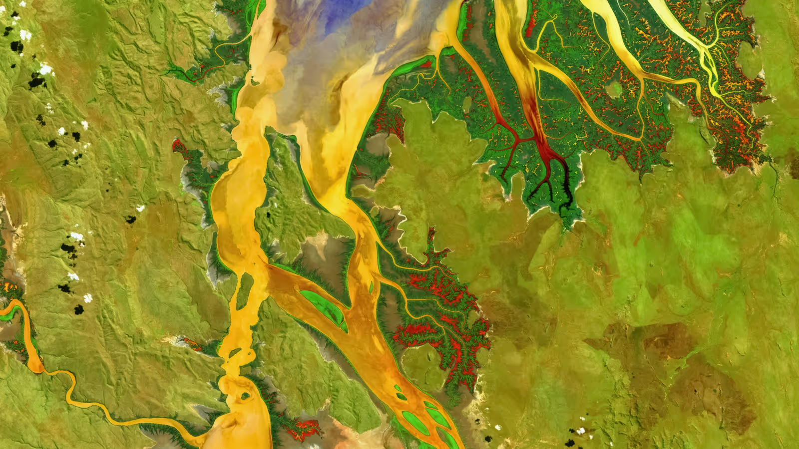
Image: Tropical estuary of the Ord River in Australia, part of the Earth as Art 4 series from the United States Geological Survey.
Landsat is a series of multispectral satellites that have been collecting data since 1972. The data is managed and distributed by the US Geological Survey. The Landsat programme is the longest-running series of satellites dedicated to mapping the land surface. With visible, infrared and thermal bands, Landsat is optimised for mapping land cover and land cover change. Clouds will affect it, so you will get better results when you apply a cloud masking block to this data. It has a spatial resolution of 30m, and data is collected every 16 days.
Landsat is one of the most used datasets in Earth Blox. With the long time series, 30m resolution, and good spatial coverage going back to the 1980s, it is the stalwart of every project looking at long-term changes of the land surface. No other dataset gives you this level of quality data over the land surface for such a long historical record.
✅ Longstanding and continuous data record. Landsat data in Earth Blox goes back to 1982.
✅ Can be used for a wide range of applications over land, ice and coastal regions.
✅ High-quality calibration of the sensors means the data is of the highest scientific integrity.
✅ At the time of writing, the entire archive is still free to access and use commercially.
❌ It is an optical sensor, so coverage is limited by clouds.
❌ The spatial resolution is only 30m (whereas ESA's Sentinel 2 is 10m).
❌ The revisit time is 16 days (about twice as long as Sentinel 2).
❌ It is raw imagery, not a data product, so you do need some technical knowledge to use the data effectively.
❌ Given the political position of the USA at the time of writing, it is unclear if this data will always remain free outside of the US.
Ground sample distance (pixel size): 30m (100m for thermal bands)
Coverage: Global terrestrial surface.
Metrics: For terrestrial vegetation mapping, the NDVI metric is a standard data layer to derive from Landsat data. Other indices can also be derived, for urban areas, snow and water.
Frequency: 16-day revisit period.
The joint NASA and U.S Geological Survey (USGS) Landsat program has provided continuous Earth observation for over 50 years. Landsat revolutionised our understanding of Earth's surface through technological advancements and innovative remote sensing techniques. Its success has served as a model for subsequent global Earth observation missions such as Sentinel 2.
The mission was a trailblazer for a number of reasons:
Landsat 8 and 9 carry two electro-optical sensors: the Operational Land Imager (OLI) and Thermal Infrared Sensor (TIRS). The OLI measures reflected and emitted energy in nine spectral bands in the visible, near-infrared, and shortwave infrared portions of the electromagnetic spectrum. TIRS measures emitted (heat) radiation in two thermal bands. Previous Landsat missions had different sensors, but in Earth Blox we use a homogenised dataset that combines imagery from all the sensors on board Landsat satellites 4,5,7,8 and 9, so that it forms one continuous dataset from 1982 to the present day. The data have also been corrected for the impacts of the atmosphere (but not clouds).
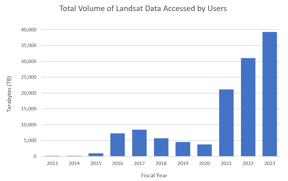
Initially, Landsat data was available for a fee, but in 2008, it was characterised as a public good and a policy of free and open access was implemented. This led to a substantial increase in its usage, sparking a rapid proliferation of scientific and commercial applications, especially in forest monitoring and agriculture. Other applications include tracking irrigation water use for water management, urban planning, flood mitigation, and carbon sequestration monitoring, to name a few examples.
For many decades, Landsat data has been the gold-standard benchmark to which other satellite instruments are compared. This reputation is built on its long lifespan (over 50 years) and the high-quality calibration of the measurements. The rigorous calibration is important because it allows accurate comparisons over time, even for very subtle changes.
The very high quality of the calibration has also led to its use by both public and private organisations worldwide for the calibration and validation of their own systems. Commercial satellite firms, including Planet, utilise Landsat data for cross-calibration and validation of their sensors.
As with all electro-optical sensors, clouds are a problem. Users of Earth Blox can use the cloud mask block to remove any scenes with greater than a threshold percentage of cloud cover, to make it easier to work with the data.
The widespread use of Landsat data underscores its continued high value. It has produced major scientific and economic benefits in areas such as agricultural crop mapping, water use, disaster support, land-cover and land-use change mapping, ecosystem and habitat mapping, and climate change monitoring. Its data is a fundamental tool powering the modern digital economy with cross-sectoral applications.
Landsat has had a particularly special role in long-term monitoring of global forest change. The Hansen Global Forest Change product that is available in Earth Blox takes advantage of the historic archive to quantify forest change since 2000. Many of the key metrics for forest carbon projects require setting a baseline over the previous 20 years, whereas Sentinel 2 only goes back to 2017.
The standard metric by which all other satellites that measure the land surface are compared is the 30x30 m Landsat pixel. When first built, this was an astonishing achievement and provided incredible details about the land surface. In the interest of continuity of measurements and for studying long time series, later Landsat missions stuck to this pixel size, even though in the 2020s it now looks a little coarse. However, it is much easier to compare like-for-like when looking at land surface changes over decades.
The United Nations Food and Agriculture Organisation’s (FAO) 0.5-hectare minimum area for a forest is likely influenced by the capabilities of Landsat imagery to reliably detect and delineate forest patches of this size. A 0.5-hectare area would roughly correspond to 5-6 pixels in Landsat imagery (at 30m resolution). At the time the FAO agreed this definition, a much smaller minimum area would have been challenging to monitor consistently at a global scale using such imagery.
Sentinel 2: This Copernicus mission has 2 identical satellites (2A and 2B) in orbit, which reduces the revisit time for data to 5 days, three times better than Landsat. The sensors it carries are similar to Landsat and so are well attuned to applications across the land surface. Like Landsat, the calibration of the data is of very high quality.
Planet: Planet offers several image products (e.g. the NICFI forest images, the Forest Carbon Diligence maps) at much higher resolution (<5m) than Landsat, and so this is good for visual interpretation or for detecting features and change that are perhaps more apparent than would be detected by Landsat. However, neither the quality of the spectral information nor the calibration is as good. This data can be purchased via Earth Blox for use in the platform.